Digital Twins of Urban Trees (TreeTwin)
Founded in 2017, the technology company greehill (www.greehill.com) has developed a method that is used for the precise recording of urban trees and provides an exact 3D digital twin of each tree. The technology used by greehill starts with mobile LiDAR systems and high-resolution panoramic photos, through machine learning to artificial intelligence, which evaluates the point clouds and photos obtained. The most modern commercial LiDAR systems currently available are used, which are able to measure more than 3.8 million times per second and thus provide comprehensive, reliable and repeatable information through high-precision 3D images and high surveying accuracy.
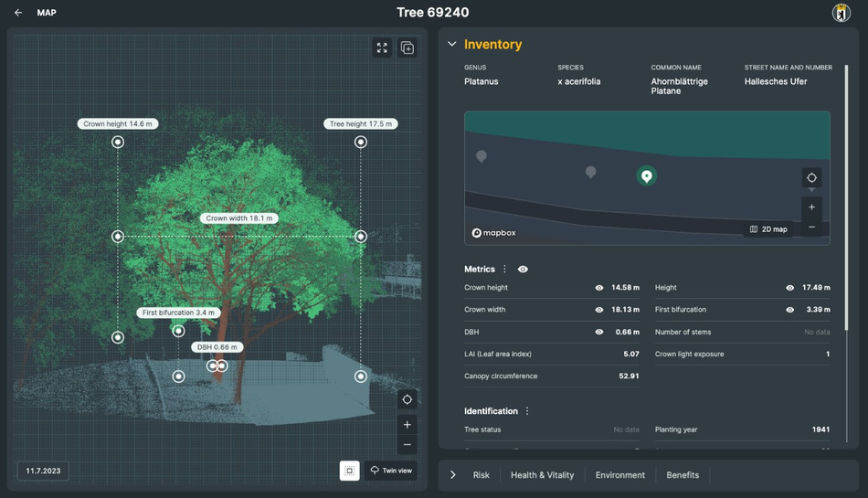
The artificial intelligence and machine learning systems developed in-house by greehill then extract each individual urban tree from the raw data obtained (point clouds and panoramic photos) and create a precise digital 3D twin. The values obtained in this way are highly accurate and can be reproduced with the same high accuracy at any time. The result is the world's first 4D Smart Tree Inventory, which is based entirely on 3D data, with the fourth dimension being time. After each subsequent scan, the system automatically compares the changes in each tree, creates an evaluation within the cohort and can show the changes in any key figures. This means that quantifying changes at the best possible resolution for canopy volume, leaf area, trunk diameter, health metrics and safety information allows tree owners to understand growth dynamics, ecosystem services, tree health and spatial distribution in detail. This method and cloud-based platform is the world's first 4D Smart Tree Inventory that enables digital tree monitoring with up to 50 different tree-relevant parameters.